The real-time situational awareness is absolutely necessary to make right tactical decisions. UAVideo Player is capable of presenting the real time platform and sensor information with the Google Earth engine. Click on the GE icon, drag the map window and dock it somewhere.

- Note
- You must be connected to Internet in order to load the GE plug-in!!! If you don't have a plug-in installed, download it from: http://www.google.com/earth/explore/products/plugin.html
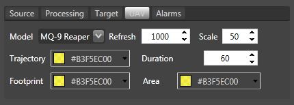
Model size, line colors and other GE related properties may be configured in the UAV section:
- Note
- In a Map Window, you can see a footprint that either taken from the telemetry (corner points) present in the stream/file or built using our algorithm. As we noticed testing numerous streams, they are not always the same. Sometimes data is simply not correct. Anyhow, you can set the mode you prefer by selecting the Footprint mode.
Select a Custom View mode and choose the appropriate view point (using a mouse). After that, click somewhere outside the map window, to resume the tracking.
Click on Area checkbox to see a total filmed area. Clicking on the resulted area polygon will display a total calculated area. Recheck Area checkbox to get an up-to-date filmed area when required.
- Note
- This feature is available only for Real Time telemetry processing.